Driving perception is not one problem but five or six, and no single dataset covers them. These nine map to the distinct sub-problems a perception stack actually has to solve.
Cityscapes is the name everyone knows, but it is research-licensed. Several of the others below are labelled public domain or MIT, which changes what you can ship, though not every label survives a look at the source: the driving-video set is a BDD100K subset under non-commercial terms.
Note the split between still images and video: identity persistence across frames is a failure mode no still-image benchmark will surface.
| Dataset | Modality | Size | Licence | Best for |
|---|---|---|---|---|
| Cityscapes | Image | ~5,000 annotated images | Research only | Urban segmentation |
| Dataset for Autonomous Cars | Image | 22,200 annotated images | MIT | Multi-class detection |
| Topview Lane | Image | 7,467 annotated images | MIT | Lane geometry |
| Traffic Sign Classification | Image | 6,165 images | CC0 | Fine-grained classes |
| Traffic Light Detection | Image | ~2,600 annotated images | CC0 | State detection |
| Road Damage Detection | Image | 4,018 files | MIT | Infrastructure survey |
| License Plate Recognition | Image | 10,100 images | CC BY 4.0 | Plate detection |
| Driving Video with Object Tracking | Video | 1,002 MP4 videos | Non-commercial | Temporal tracking |
| Pothole Image Segmentation | Image | 780 annotated images | Apache 2.0 | Small-set segmentation |
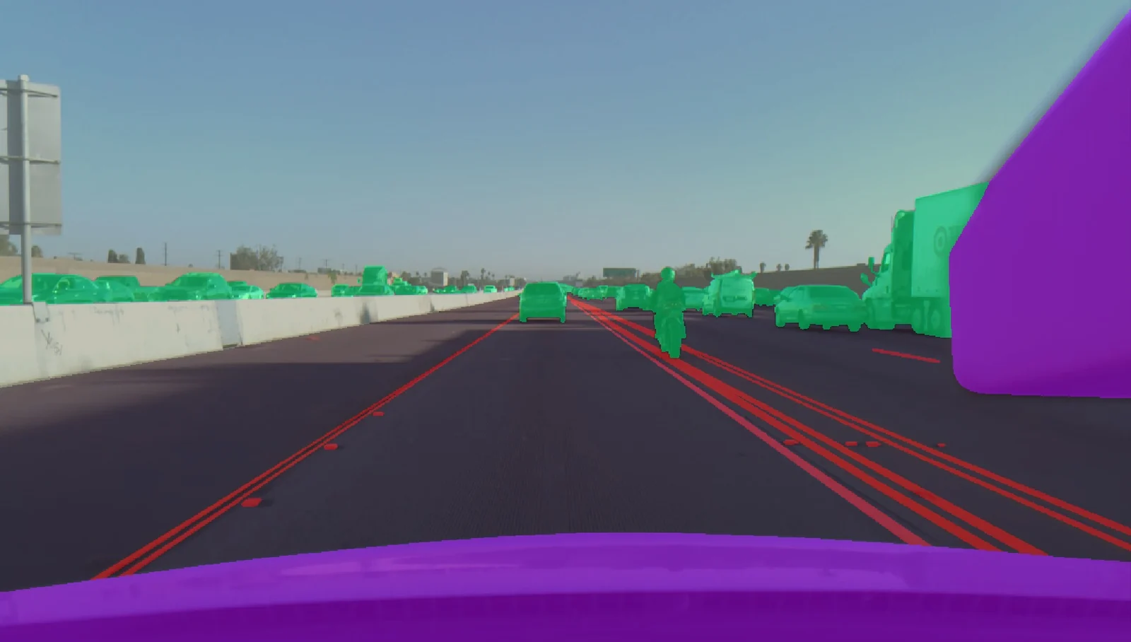
Cityscapes
- Size
- ~5,000 annotated images
- Licence
- Research licence
Around 5,000 high-resolution street scenes from European cities with dense pixel annotations in JSON. The images are deliberately mundane — ordinary traffic in ordinary weather — which is what makes it a fair test of semantic segmentation rather than a showcase.
Semantic and instance segmentation for driving. Covered by the Cityscapes licence agreement, which rules out commercial use.
Source: innovatiana.com/datasets
Dataset for Autonomous Cars
- Size
- 22,200 annotated images
- Licence
- MIT (Udacity's original release); this copy is labelled CC0
22,200 annotated images tagged for car, truck, pedestrian, cyclist and traffic light. Udacity released the original under MIT — attribution rather than public domain, whatever this copy's CC0 tag says — and it is large enough to train a usable detector from scratch, which is rare in this category: most driving data is access-gated.
Multi-class object detection for a driving stack, with an attribution notice as the main obligation; Udacity says the labels are not complete and the data was meant for educational use.
Source: innovatiana.com/datasets
Topview Lane
- Size
- 7,467 annotated images
- Licence
- MIT
7,467 annotated images (JPEGs with COCO-format segmentation labels), shot from a top-down view. The overhead perspective removes the vanishing-point distortion that makes lane detection hard from a windscreen camera, so it isolates the geometry problem.
Lane detection and drivable-area segmentation in bird's-eye-view pipelines.
Source: innovatiana.com/datasets
Traffic Sign Classification
- Size
- ~6,165 images across 58 classes
- Licence
- CC0 1.0
Around 6,165 images across 58 sign classes, with a labels CSV and a separate test set of roughly 2,000 files. The class count is the challenge: several signs differ only by a digit or an arrow direction.
Fine-grained classification where the inter-class differences are small and deliberate.
Source: innovatiana.com/datasets
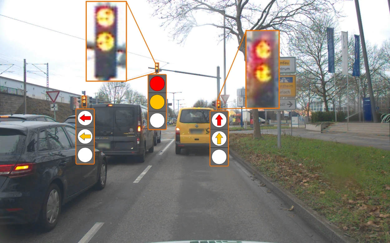
Traffic Light Detection
- Size
- ~2,600 annotated images
- Licence
- CC0 1.0
Roughly 2,600 annotated images, out of 3,000 dash-cam photos taken from a CCF BDCI competition set, labelled by both category and light colour; the CC0 tag is the uploader's, so check the competition's terms. Detecting the box is the easy half; reading the state correctly under glare, at night and against a bright sky is the half that matters.
Joint detection and state classification — a small dataset that exposes a genuinely hard failure mode.
Source: innovatiana.com/datasets
Road Damage Detection
- Size
- 4,018 files (2,000+ images)
- Licence
- MIT
More than 2,000 road images with detection annotations, 4,018 files in all, covering cracks, potholes and manholes. It is labelled MIT, and its author says he took the images himself, with a GoPro on a moving vehicle and a smartphone, around Rome and Sacrofano in Italy.
Automated road-condition surveying from a vehicle-mounted or drone camera.
Source: innovatiana.com/datasets
License Plate Recognition
- Size
- 10,100 images
- Licence
- CC BY 4.0
10,100 images with annotations in XML and CSV. Plate recognition is a two-stage problem — locate the plate, then read it — and this set, exported from Roboflow Universe, labels plate bounding boxes, so it trains the locating stage; reading the characters needs text labels from elsewhere.
Plate detection, as the first stage of a recognition pipeline.
Source: innovatiana.com/datasets
Driving Video with Object Tracking
- Size
- 1,002 MP4 videos
- Licence
- BDD100K licence, non-commercial (copy labelled CC0)
1,002 MP4 clips with CSV tracking annotations, a subset of BDD100K. The CC0 tag is the uploader's: BDD100K's own licence allows only educational, research and not-for-profit use. Video rather than stills, so identity has to persist across frames — the failure mode here is ID switching when two vehicles cross, which no still-image benchmark will catch.
Multi-object tracking and re-identification across occlusions.
Source: innovatiana.com/datasets
Pothole Image Segmentation
- Size
- 780 annotated images
- Licence
- Apache 2.0
780 images at 640×640 in YOLOv8 format, split 720 train and 60 validation. Small by design — it is a good test of whether your augmentation and transfer-learning strategy works when data is genuinely scarce.
Segmentation fine-tuning from a pre-trained backbone on a deliberately small set.
Source: innovatiana.com/datasets
How this list was put together
All nine are listed in Innovatiana's open-dataset catalogue with a published licence and size; each entry links to its source page.
Where a dataset is covered by a bespoke research licence rather than a standard one, the chip says so — read the original terms before commercial deployment.